")
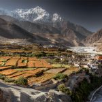
Annapurna Circuit trek is the world’s most popular 150-mile long trek that encircles the entire Annapurna massif and awards with stunning views of Annapurna Himalayan range from Annapurna I (8,091m) the 10th highest mountain in the world, Machhapuchhre, Nilgiri, Dhaulagiri ( 8,167m ) and Manaslu (8,163m) ), the world’s 7th highest mountain. The trail to Annapurna Circuit begins in an anti-clockwise direction. While trekking you pass through spectacular villages inhabited by different ethnic groups of people of the country and landscapes from lowland farming terrain to alpine meadows and Tibet-like country on the northern slopes of the Himalaya.
From Kathmandu we begin the trek to Bhulbhule (830m), the initial days of the trek involve hike through rice farms, forests, and villages in the lower section of the Annapurna Conservation Area. After reaching Manang (3500m) which offers the enjoyment of the mountain views. No place anywhere in Nepal looks similar to Mustangs’ landscape. It lies behind the Annapurna range in rain shadow area which blocks the rain and is desert-like landscape. From Manang, you will continue walking ascending slowly and on day 12 of the trek you cross the classic Thorung La pass at 5416m and set out for Muktinath, an important pilgrimage site for Hindus and Buddhists. Crossing Thorong La pass is technically easy and you would have a wonderful experience.
After crossing Thorong La pass you make easy but long descend into the Kali Gandaki river valley, witnessing Annapurna and Dhaulagiri mountains towering on either side. Then, you will visit Muktinath temple. If you are religiously inclined, you can take a bath in 108 taps and 2 ponds in the temple premises to relieve yourself of all your sins as per the sayings of Hindu religion.
Further down you will reach Tatopani on day 16 where you take bath in natural hot springs and relax. Then, you climb up Poon Hill, above Ghorepani, to enjoy magnificent mountain views. While returning to Pokhara you will walk through many beautiful Gurung villages that dominate this ancient trading salt route between Tibet and India. Accommodation and food are provided in every local lodge along the trail. The best time for this trek is from March to May, as you will see the colorful Rhododendron blooming along the trail at the lower part of the Annapurna region.
(Kathmandu – Besisahar )
( Besisahar – Dharapani )
(Muktinath – Pokhara )
(Pokhara – Kathmandu )
Our staffs from Adventure Gandaki Treks and Expedition will be there at the Airport to Pick you up. You will be then transferred to 3 star Hotel in Kathmandu.
Drive to Besi Sahar covering about 173 kilometers or so from Kathmandu to Besi Sahar, where the trek starts. Drive duration: 7 Hrs
Besi Sahar (823 m) is the main town of Lamjung district. Until recently this market town of 2000 inhabitants was called Besigaon. However, since the opening of the road to Manang, in the late seventies, the village became a compulsory stop over for those who go trekking around the Annapurna and was renamed Besi Sahar.
After reaching Besisahar to avoing the motorable trail we take a 3- 4 Hr of Jeep drive to Dharapani . We aty overnight at the teahouses in Dharapani
It takes 45 minutes to reach the village of Bagarchap (2164m), which literally means ‘the river bank’. Bagarchap marks the barrier between the humid valleys of the south, which is to be crossed on the way, and dry regions of the high- Marsysngdi. That the monsoon is more or less absent in this region is evident by the change in vegetation.
From Bagarchap, it will take an hour to climb up to the hamlet of Dhanagya (2300m), lunch spot. After lunch it takes us about 2-½ hrs to 3 hrs through the hamlet of Thanchock and Besi Salla (which means “the Garden of Pines”) to reach Kodo (and also called Koto) meaning ‘Millet’ and then to the village of Kyupar (2600m). Outside the village a police check post controls the access to the Nar Phu Khola Valley, which leads to Tibet. Chame, the headquarter of Manang District, is forty five minutes walk away.
After reaching the school at Chame, move to cross the bridge to get to the northern bank of Marsyangdi. Walk along the river to reach the village of Bratang (2919m), mainly populated by Tibetans. Stop for Lunch. On the way to Bratang, pass through a splendid pine forest with splendid views of Lamjung and Annapurna II and IV.
After lunch it’s about two hours walk to reach the top, where trekkers traditionally plant a pine sapling, not only to establish that they have made it to the top, but also to contribute to the reforestation of the area. Go down to Pisang (3185m) from here and it takes about an hour to reach there. There are neither houses nor any water resources on the way down.
After crossing the Pisang Khola there is a forty-five minutes steep climb up to a steep pass. From the top of the pass, get a glimpse of Paunda Danda (4655m), Mount Pisang and Manang valley, with Mount Tilicho in front. On the way down to Hongde come across a check post where the trekking permits will be rechecked. Lunch at Hongde.
After Hongde, the valley widens with the Annapurnas III and IV (7555m and 7525m) to the left, East and West Chulus(6584m and 6419m) on the right, towards the horizon, there are views of peaks of Mount Thoroung(6481m) and to the east, the crown of Mount Pissang. From Hongde, climb up to the ancient village of Braga (3505m).
Have leisurely time to wander around Braga to see this picturesque village with its flat roofed houses and to visit Gompa, not only the largest in the region but also the richest with its fine collection of thangkas (religious scroll paintings) and prayer books. It takes only forty-five minutes to reach Manang from here, which sits on the plateau of 3530 meters.
Today, we take a rest and acclimatize to the altitude. We will visit villages, Gangapurna glacier, Gangapurna lake, and mountains. We will experience high altitude here.
The Khangsar trail goes downhill to a chorten, and then turns northwest and heads down towards the river. Stay on a north bank and head west, following a trail alongside the river. Follow the power lines along the ridge on a wide trail and then traverse along the south side of the ridge through a blue pine forest. Cross the suspension bridge and climb up the ridge. Khangsar is collection of traditional building surrounding a large village square. The top storey of each house has been whitewashed, but a complex web of power lines detracts somewhat from the picturesque aspect of the village.
Beyond Khangsar and the Tilicho Base Camp, the trail climbs steeply to a small chorten, then climb more gently through juniper and sea buckthorn bushes to a crest at 3900 m. Traverse into a side valley, cross a stream and climb to some herders huts and a trail junction at 4050 m. The high trail to Tilicho Base Camp leads to the right, which is the safest route to Tilicho Tal.
Stay overnight at Tilicho Base Camp
The trail to Tilicho Tal starts up a valley. It. Then, traverses onto a moraine making a long climb to 4710 m. There are outstanding views of Khangsar Kang, Tarke Kang, and Gangapurna as well as great views down the valley to Manang and Upper Pisang. The trail then makes a series of steep switchbacks, climbing for an hour to a false summit and on to a crest at 5010 m. From here to the lake the trail is lined with hundreds of large stone slabs set on end. Passing two Lakes, the trail crest at a cairn and prayer flags where one will have their first view of the Lake (4920 m), 4 Km long and 2.5 Km wide. It is the lake situated at the highest place. After visiting Tilicho Lake, backtrack to Khangsar.
Stay overnight at Khangsar (4250 m)
From Khangsar, the trail goes descending to Gungsang crossing Jharsang khola. The route passes through sparse forests of Juniper, rose and berry, a few meadows and Mani. Beyond is Yak Kharka, also known as Koche. Lunch at Yak Kharka and continue trek to Churi Lattar.
After leaving Churi Lattar the path climbs up till Thorung Phedi. These Himalayan pastures are domains of yak, a bovine of Tibetan origin, reared for its wool, milk and to transportation of goods. The thar, a kind of wild goat that lives in herds, is also found here.
It takes about one hour to reach Thorung Phedi after lunch. Thorung Phedi means ‘foot of the hill’ and it is situated at a height of 4220m on a small hill overlooking a high plateau.
Stay overnight at Thorung Phedi
We have to cross about twenty hills on the way to reach the summit, Throungla Pass at 5,415 meters and it takes about 4 ½ -5 hrs to reach there. On the way up one sees many prayer flags several cairns (small mounds of rock). From the top one gets the views of the Yakgawa Kang or Thorungse (6481m) to the north, and Khatung Kang (6484) to the south and the Annapurnas along with the Gangapurna to the southeast. In the horizon to the west, Dhaulagiri (8169m) and Mount Tukuche (6920m) are also visible. From the summit the descent to Muktinath (3802m) takes about three hours and the difference in altitude is of 1600m.
We will drive 7-8 Hrs in a bus from Muktinath to Pokhara
We drive 200 KM from Pokhara to Kathmandu on a Tourist Bus , and come back to the hotel
According to your Flight Schedule , we will Arrange Airport Drop at the End of your Trip
Your accomodation in a trek will be on twin sharing basis. Your hotels in mountains while on trek will be very basic standard. We it as a trekkers lodge/tea houses. Tea houses wont be very luxurous as on the cities but beds will be comfortable . we will provide you with the best standard type hotel available in the area.
Food is of a very good quality, and we recommend you try local foods such as dal bhat (lentil stew with rice and curried potatoes or meat), boiled potatoes with chilli sauce, Sherpa stew (meat, potatoes, vegetables in a rich sauce) or curry with rice. These are the staple foods for Sherpa people but every lodge will also offer a wide range of western meals:
Breakfast – Eggs (fried, boiled), omelettes, toast, pancakes, Tibetan bread, muesli, porridge, tea, coffee, chocolate.
Lunch/dinner – Soups (tomato, garlic, vegetable, mushrooms etc), veg fried rice, dal bhat, curry w/rice, noodles (mix fried, veg, egg, w/cheese), macaroni, spring rolls (veg, egg, cheese, mixed), momo (boiled or fried mini pasties with either veg or meat), pizza (all types), fried potatoes (w/veg or cheese), chips, buff steak (water buffalo, occasionally yak), lasagne.
Dessert – apple pie, fruit cocktail, chocolate cake, rice pudding, snickers pie!
The Essentials
Optional
Nepal Trekking Season generally known best as two seasons after falls and after the winter. The following month mid of September to mid of December consider ever best season of trekking in Himalayas. During this period of months have pleasant climate condition not so hot and cold and visibility of mountain are crystal clear. There is another best season of trekking Nepal after winter when sun getting more warmer in spring time may trekkers to Himalayas can again enjoy comfortable climate condition.